
11e - ROQUETTE
Quartiers Administratifs
Part of an ongoing project to walk and photograph every neighborhood in Paris, this page explores the Administrative Quarter: 11e - Roquette through maps, district identity, history, and photography.




The Map
Download the Paris Arrondissements Map
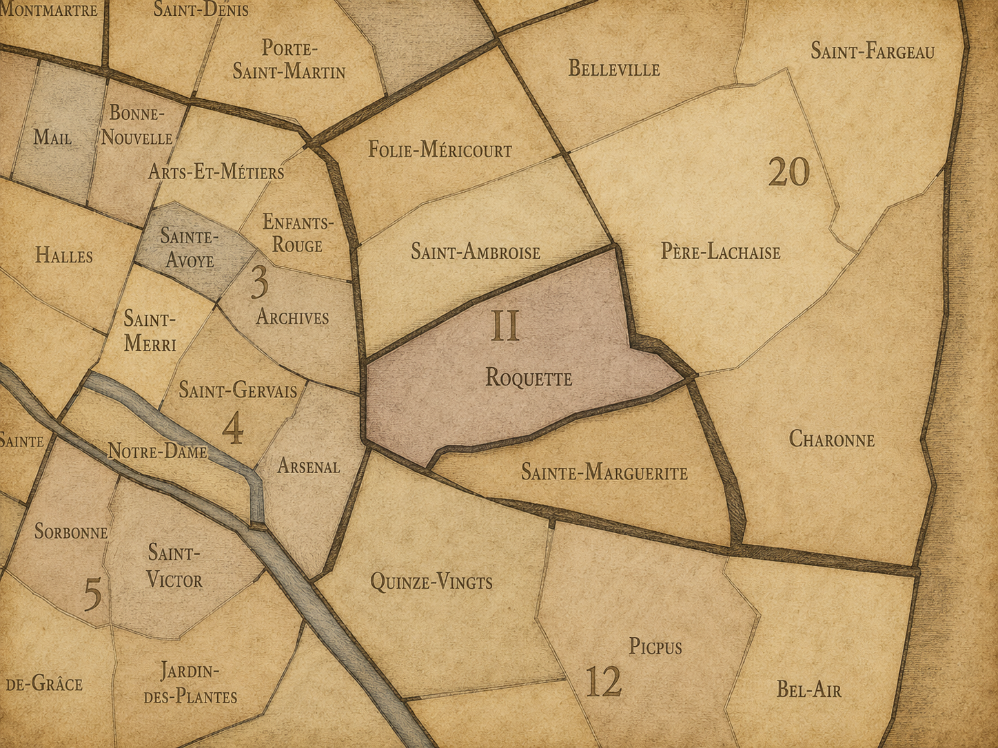
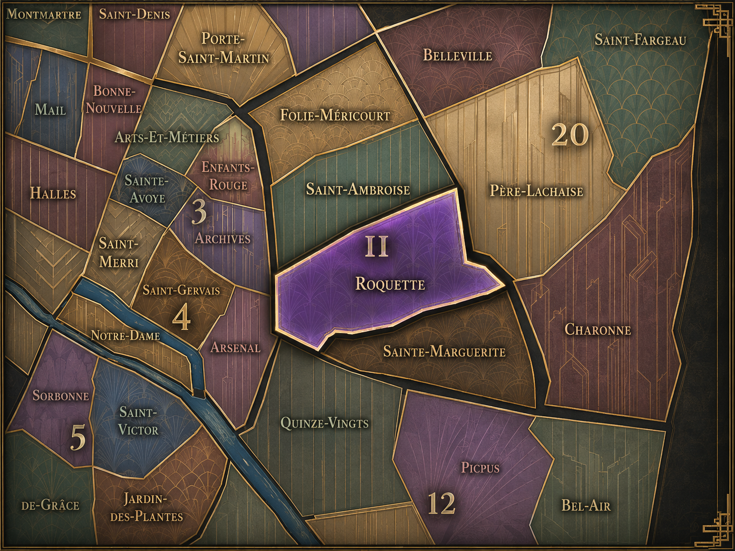
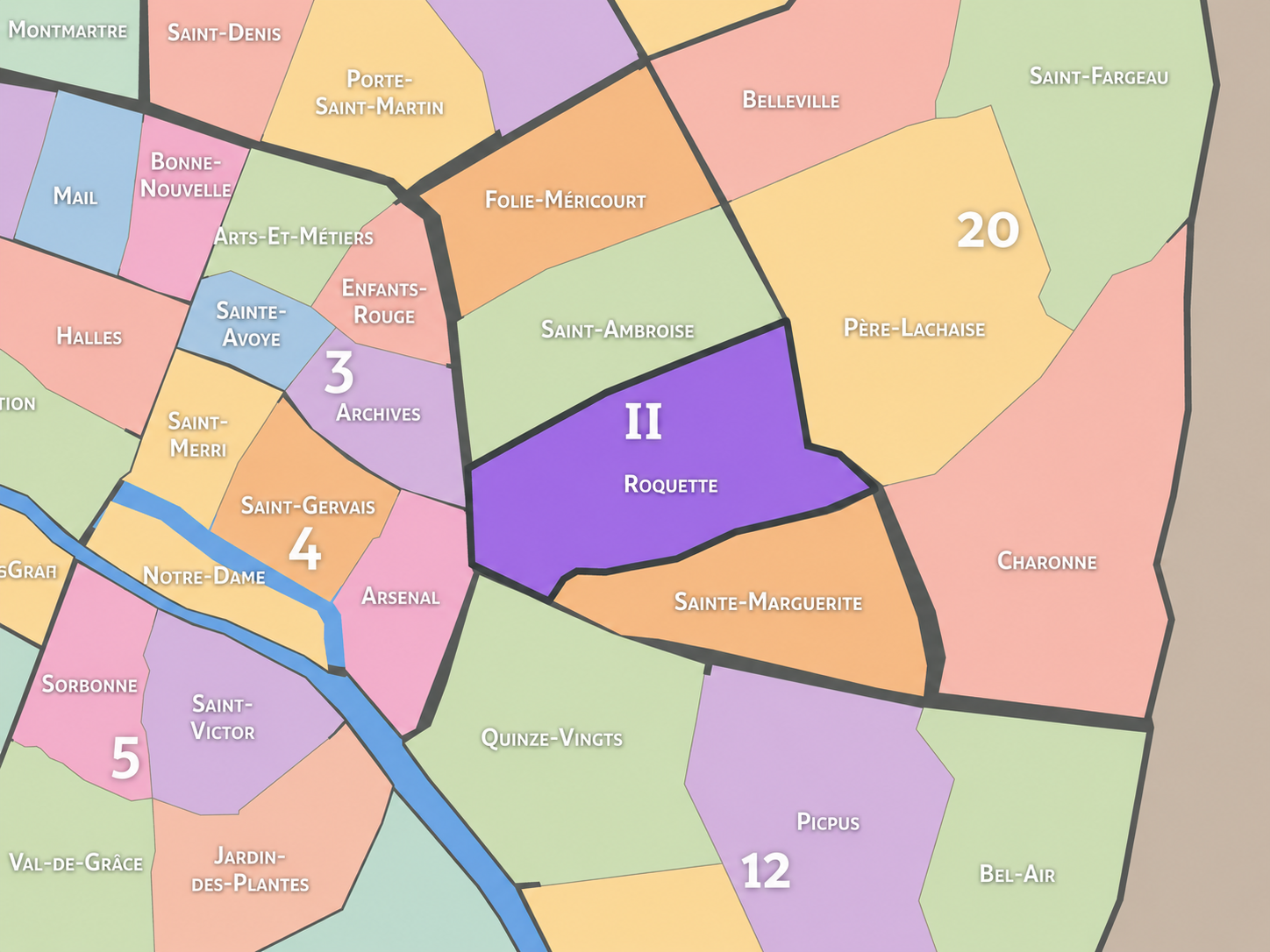
Geographic Setting
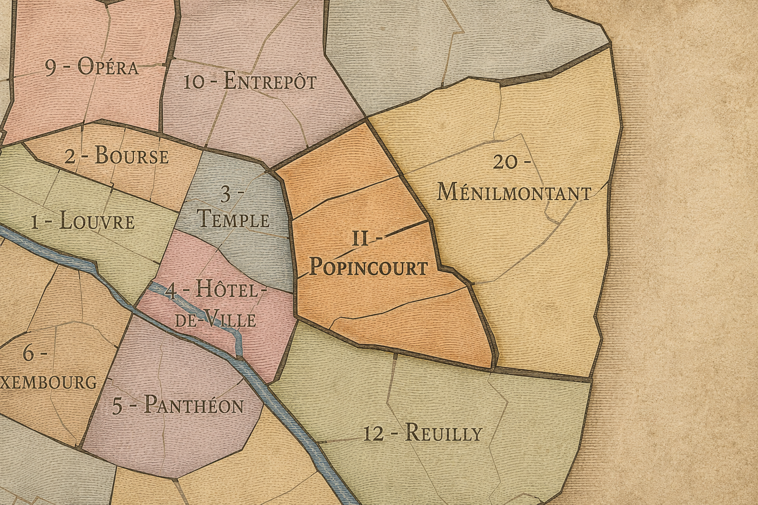
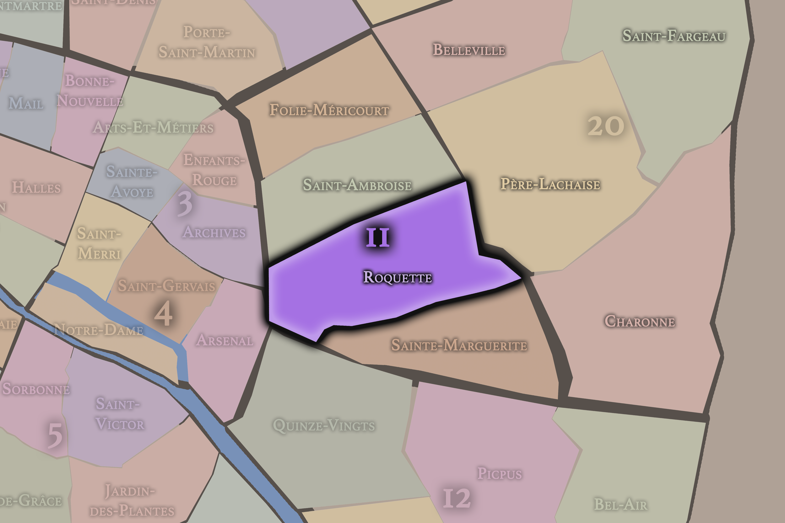
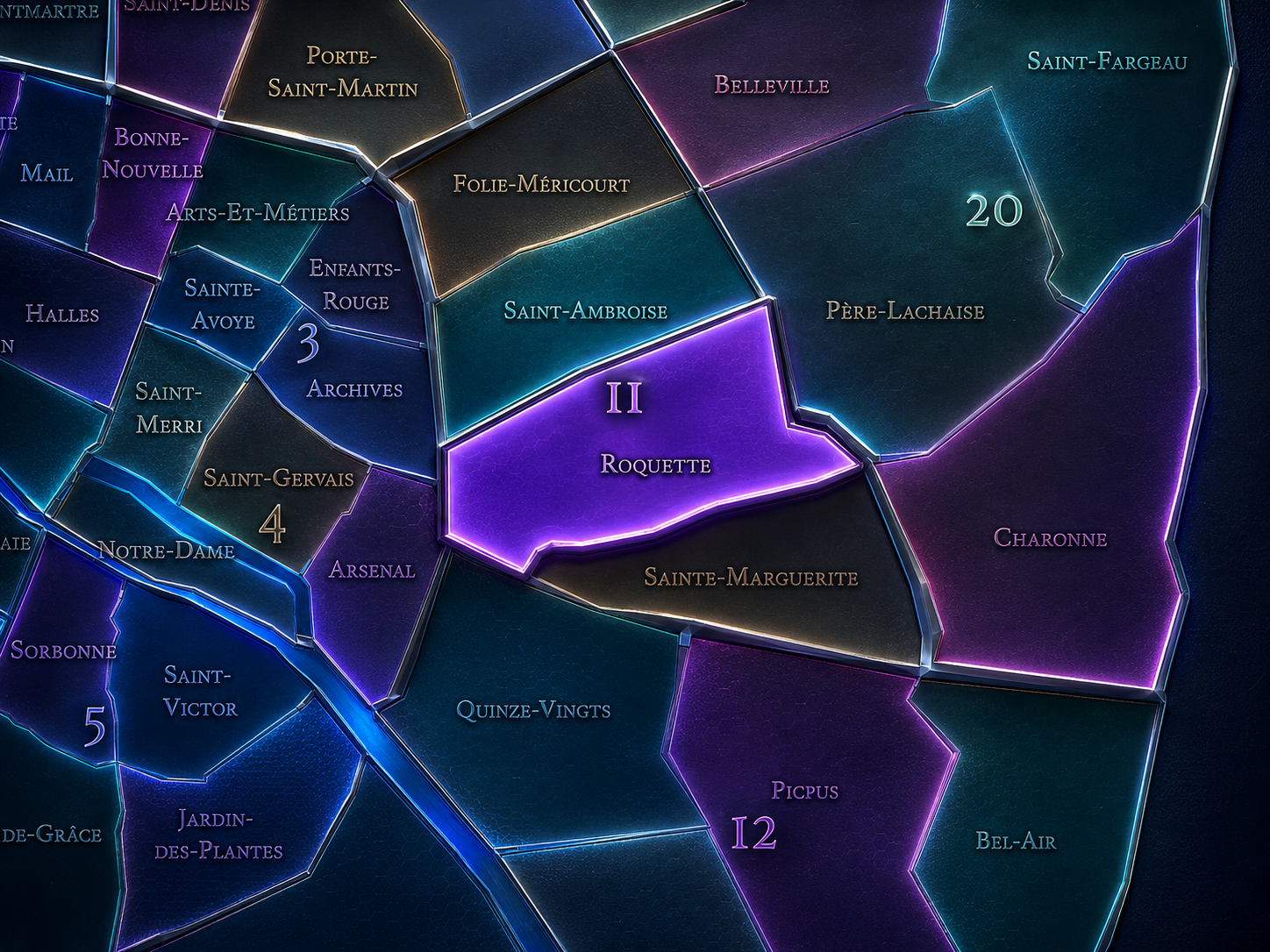
Roquette occupies the southwestern portion of the 11th arrondissement, where the Bastille landscape opens eastward into one of Paris’s historically most charged working-class and popular districts. It lies east of the 4th arrondissement’s Arsenal quarter, south of Saint-Ambroise and Folie-Méricourt, west of Sainte-Marguerite, and north of the 12th arrondissement’s Quinze-Vingts and Picpus quarters. Its geography is shaped by the powerful convergence of Bastille, Père-Lachaise, Voltaire, Charonne, Popincourt, and the old eastern faubourgs.
The quarter’s principal streets and landmarks include Rue de la Roquette, Rue de Lappe, Rue de Charonne, Boulevard Voltaire, Boulevard Richard-Lenoir, Avenue Parmentier, Place Léon-Blum, Place de la Bastille at its western threshold, and the approaches toward Père-Lachaise to the east. It is a district of movement and memory: roads leading out from Bastille, dense residential blocks, former prison sites, nightlife corridors, workshops, cafés, courtyards, and streets where popular Paris has repeatedly asserted itself.
Unlike Folie-Méricourt, whose identity is more tied to Oberkampf, République, nightlife, and the northern edge of the 11th, or Sainte-Marguerite, whose character turns toward the Faubourg Saint-Antoine and craft traditions, Roquette is more directly shaped by Bastille’s eastern afterlife. It is the quarter where revolutionary symbolism, working-class history, prison memory, and contemporary urban energy meet in one of the most layered landscapes of eastern Paris.
Administrative Quarter Identity
Etymology and Origins
The name Roquette comes from the old locality known as La Roquette, whose name is generally associated with the plant roquette, or arugula / rocket, that grew in the area when it lay beyond the denser urban core. Like many eastern Parisian place-names, it preserves a memory of semi-rural land, gardens, fields, and roads before the neighborhood became fully absorbed into the capital.
That modest botanical origin contrasts sharply with the quarter’s later history. Roquette would become associated not with open ground, but with prisons, executions, working-class density, revolutionary memory, nightlife, and the intense urban life of the eastern faubourgs. The name still carries the softness of an older landscape, even though the modern quarter is anything but pastoral.
This contrast gives Roquette much of its power. A name rooted in vegetation became attached to one of Paris’s most socially and politically charged districts. In that transformation, the quarter tells a familiar Parisian story: rural edge becoming faubourg, faubourg becoming working city, working city becoming cultural memory, and cultural memory becoming one of the key layers of contemporary neighborhood identity.
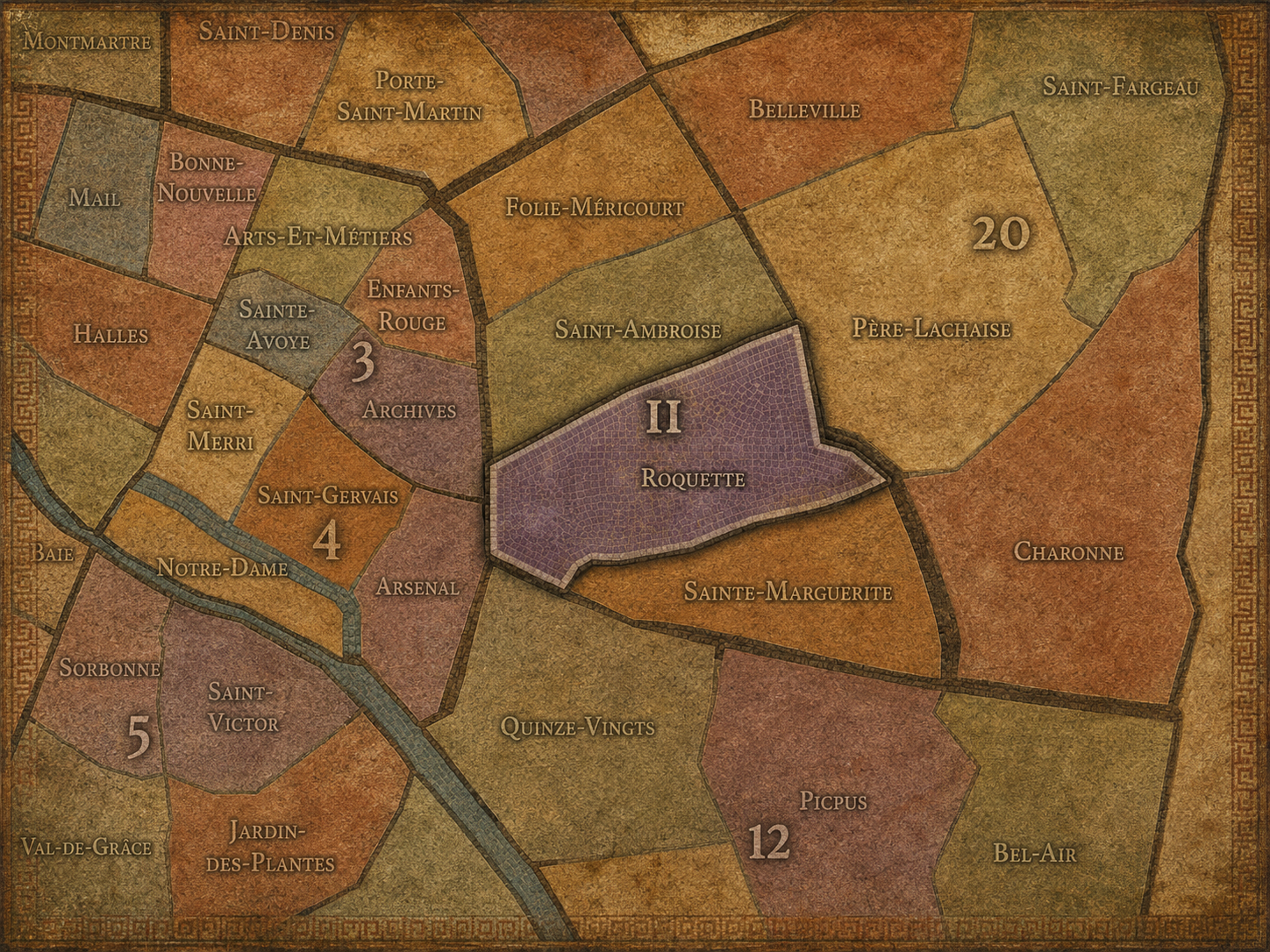
Within the official geography of Paris, Roquette is one of the four administrative quarters of the 11th arrondissement, alongside Folie-Méricourt, Saint-Ambroise, and Sainte-Marguerite. It occupies the arrondissement’s southwestern sector, giving formal civic shape to the area between Bastille, Voltaire, Charonne, Père-Lachaise, and the broader eastern faubourg landscape.
As an administrative quarter, Roquette helps clarify an area often described through stronger everyday or cultural names: Bastille, Popincourt, Père-Lachaise, Voltaire, Charonne, Rue de Lappe, or the lower 11th. The official name gathers these overlapping geographies into one mapped unit. It reminds us that the eastern side of Bastille is not merely an extension of the square, but a distinct quarter with its own social, institutional, and historical identity.
This civic frame is especially valuable because Roquette has carried several powerful but different identities over time. It has been a road district, a working-class neighborhood, a prison landscape, a site of execution, a nightlife zone, and a residential-cultural quarter. The administrative name allows these layers to be read together rather than scattered under separate landmark names.
Civic Framework
Roquette differs from the other quarters of the 11th arrondissement through its unusually strong combination of Bastille proximity, prison memory, working-class history, and contemporary nightlife. Folie-Méricourt is more northern and social, tied to République, Oberkampf, Jean-Pierre-Timbaud, and the dense café and bar culture of the upper 11th. Saint-Ambroise is more central and parish-oriented, shaped by Boulevard Voltaire, civic institutions, and residential streets. Sainte-Marguerite is more closely connected to the Faubourg Saint-Antoine, furniture trades, craft memory, and the eastern continuation of working Paris.
Roquette is more dramatic in historical tone. Its identity is shaped by the long road of Rue de la Roquette, the shadow of former prisons, the memory of condemned prisoners taken toward execution, the popular life around Bastille, and the nightlife corridors that later gave the district a more festive reputation. The quarter holds both joy and severity, public gathering and institutional violence, daily life and historical rupture.
It should also be distinguished from Bastille itself. Bastille is a symbolic square and a larger cultural district crossing arrondissement boundaries. Roquette is the 11th arrondissement quarter that extends east from that symbolic threshold into the lived streets beyond. It is not the fortress site, but one of the neighborhoods most deeply shaped by what Bastille came to mean.
Neighborhood Distinction
Parisian Identity
Roquette expresses Paris as a city of popular force. It belongs to the eastern side of the capital, where working people, artisans, political crowds, small businesses, migrants, prisoners, performers, revelers, and residents have all contributed to the neighborhood’s identity. This is not Paris as courtly display, aristocratic enclosure, or monumental calm. It is Paris as pressure — social, political, emotional, and urban.
The quarter also reveals the complicated relationship between freedom and confinement. Its proximity to Bastille evokes liberation and revolution, while its own history includes the prisons of La Roquette and the grim memory of execution. Few quarters hold such a stark juxtaposition: the myth of freedom at one end of the landscape, the reality of incarceration and punishment within the neighborhood itself.
Yet Roquette is not only a somber district. Its streets have also been deeply social: cafés, dance halls, bars, restaurants, music, late-night movement, and the urban pleasures of the Bastille / Rue de Lappe world. The quarter’s Parisian identity lies in this doubleness. It is a place of struggle and release, memory and nightlife, ordinary residence and historical charge.
Neighborhood Connections
Every administrative quarter belongs to a wider Parisian fabric. These connections place Folie-Méricourt within the city’s civic, participatory, and cultural geography:
-
11e - Popincourt
-

Belleville - Saint-Maur • République - Saint-Ambroise
The History
The origins of Roquette lie in the eastern outskirts of Paris, beyond the older fortified city and along roads leading toward Charonne, Montreuil, and the working faubourgs east of Bastille. Before the modern quarter took shape, the area contained fields, gardens, religious lands, small settlements, and routes connecting the city to the villages and productive landscapes beyond it.
The old name La Roquette suggests this pre-urban condition. Like Folie-Méricourt and other eastern quarters, Roquette began as part of the outer land gradually drawn into the expanding city. Its early identity was shaped less by formal monuments than by roads, land use, and the practical geography of approach.
The decisive long-term transformation came from its position near Bastille and the Faubourg Saint-Antoine. As eastern Paris became more densely inhabited by artisans, workers, and small industries, Roquette became part of a powerful working-class geography. Its origin as an outer landscape gave way to an urban identity built around labor, movement, and popular politics.
Origins
16th–17th Century
In the 16th and 17th centuries, the future Roquette quarter still lay outside the densest center of Paris. The eastern lands beyond Bastille were shaped by roads, gardens, convents, fields, workshops, and the early development of faubourg settlement. The area was close enough to the city to be influenced by its growth, but still open enough to retain traces of a semi-rural edge.
The nearby Faubourg Saint-Antoine became increasingly important during this period, especially through craft and furniture-related trades. Though Sainte-Marguerite would become more directly identified with that craft geography, Roquette shared the broader eastern atmosphere of working streets, artisan life, and urban expansion beyond the old city walls.
The presence of Bastille to the west also mattered. Long before the fortress became a revolutionary symbol, it shaped the geography of the eastern gate and the routes beyond it. Roquette developed in the orbit of that threshold, along roads where the city’s authority, outer districts, and popular life came into contact.
In the 18th century, Roquette became more deeply integrated into the life of the eastern faubourgs. The area grew denser with housing, workshops, gardens, religious institutions, small businesses, and the ordinary life of people who worked in and around the expanding city. It was not a prestigious western quarter, but part of the productive and socially active east.
The Revolution gave the surrounding landscape extraordinary symbolic force. Bastille’s fall transformed the western threshold of the quarter into one of the defining sites of modern French political memory. Roquette, lying just east of that symbolic rupture, belonged to the broader geography of popular Paris — the Paris of artisans, workers, crowds, and political urgency.
This period helped establish the quarter’s association with social intensity. The eastern faubourgs were not passive background to the events of the city. They helped make Paris politically volatile, organized, and alive. Roquette inherited that role as one of the streetscapes where popular identity and urban transformation would continue into the 19th century.
18th Century
19th Century
The 19th century gave Roquette much of its most difficult historical weight. The district became associated with the prisons of La Roquette: the Grande Roquette and Petite Roquette. These institutions made the quarter part of Paris’s penal geography, transforming a popular eastern district into a landscape marked by confinement, punishment, and execution.
The Grande Roquette became especially associated with condemned prisoners and executions. The route from prison to execution entered the memory of the quarter, placing Roquette within one of the darker urban histories of modern Paris. The neighborhood’s name, once tied to a plant and former open ground, became linked to the machinery of the state, criminal justice, and public death.
At the same time, Roquette remained a living working-class district. Streets around Bastille, Charonne, and the lower 11th held workshops, cafés, modest housing, small commerce, and the social life of eastern Paris. The quarter’s 19th-century identity therefore cannot be reduced to the prisons alone. It was a place where ordinary labor and extraordinary violence existed in the same urban field.
In the early and mid 20th century, Roquette remained deeply tied to the popular, working, and prison-marked history of the 11th arrondissement. The memory of La Roquette’s prisons continued to shape the district, even as parts of that institutional landscape were demolished, repurposed, or absorbed into later urban development. The quarter carried absence as much as presence: former walls, former routes, former sites of confinement.
The surrounding streets continued to support a mixed working and residential life. The Bastille area and Rue de Lappe became associated with dance halls, cafés, nightlife, and popular entertainment. This gave the quarter another powerful identity: not only punishment and labor, but release, music, and social gathering. Roquette became one of the places where working Paris went out at night.
During the upheavals of war, occupation, liberation, and postwar recovery, the quarter remained part of eastern Paris’s dense social fabric. Its streets held memory, scarcity, resilience, and the everyday life of a city under pressure. The former prison landscape and the popular nightlife geography together made Roquette a quarter of both shadow and survival.
Early–Mid 20th Century
Late 20th Century
In the late 20th century, Roquette underwent significant transformation as the Bastille area became increasingly associated with nightlife, restaurants, bars, music venues, and a younger urban culture. The opening of the Opéra Bastille nearby in 1989 added a major cultural institution to the broader landscape, strengthening Bastille’s role as a contemporary cultural and evening destination.
Rue de Lappe and surrounding streets became especially associated with bars, clubs, and nightlife, shifting the quarter’s public image toward entertainment and sociability. This transformation layered over older working-class, prison, and craft histories without fully erasing them. Roquette became both historic and fashionable, both popular and increasingly gentrified.
The late 20th century also brought renewed attention to memory. The sites of former prisons and executions, once central to the quarter’s identity, became less visible in the everyday streetscape. This invisibility makes historical interpretation especially important. Roquette’s past is not always obvious, but it remains essential to understanding the district’s moral and urban depth.
In the 21st century, Roquette is one of the most active and layered quarters of the 11th arrondissement. It connects Bastille, Voltaire, Charonne, Père-Lachaise, Rue de Lappe, and the residential-commercial streets of the lower 11th. Its identity now includes cafés, bars, restaurants, apartments, schools, shops, small offices, cultural venues, memorial traces, and the daily movement of people between the symbolic center of Bastille and the deeper east of Paris.
The quarter today balances many versions of itself. It is nightlife district and residential neighborhood, prison memory and leisure landscape, working-class inheritance and gentrified address, historical seam and contemporary destination. This complexity is not a flaw. It is the essence of Roquette’s identity. The quarter has always held contradictions close together.
For CityNeighborhoods: Paris, Roquette is essential because it reveals how official neighborhood geography can preserve difficult histories beneath contemporary urban life. A visitor may come for Bastille or Rue de Lappe and never realize the depth of the prison landscape, the working-class history, or the old eastern road structure beneath their feet. The administrative quarter gives those layers a frame.
21st Century
Spirit and Legacy
Roquette is the quarter where eastern Paris holds freedom and confinement in the same memory. Its spirit is popular, restless, wounded, and alive. It belongs to Bastille’s shadow and Rue de la Roquette’s long road, to former prisons and crowded bars, to workers’ streets and late-night music, to execution memory and everyday reinvention.
Its legacy is the transformation of a difficult urban past into a living neighborhood that still refuses simplicity. Fields became faubourg. Faubourg became working district. Working district became prison landscape. Prison landscape became memory. Around that memory, nightlife, residence, culture, and contemporary Paris continued to grow. Roquette did not erase its past; it absorbed it unevenly, as cities often do.
To walk Roquette is to encounter Paris at one of its most human tensions. The quarter reminds us that neighborhoods are not only made from beauty, commerce, or charm. They are also made from justice, punishment, labor, grief, pleasure, survival, and release. In Roquette, Paris does not present a single face. It presents a layered one — fierce, social, haunted, and still moving.
The Photography
The arrondissements do not share a single visual identity. Instead, they organize Paris into twenty broad visual fields, each gathering its own combination of landmarks, streetscapes, institutions, residential districts, commercial corridors, parks, rail stations, markets, cemeteries, and riverfront edges.
Some arrondissements are defined by monumental scale: royal palaces, ceremonial avenues, government buildings, museums, formal gardens, and internationally recognized landmarks. Others are shaped by hills, canals, rail gateways, apartment-lined boulevards, neighborhood markets, former village streets, industrial remnants, parks, or the quieter rhythms of residential Paris. The arrondissement system gives these varied landscapes a civic frame, allowing the city to be read not as one visual language, but as a sequence of overlapping Parisian atmospheres.

Visual Identity
Through The Lens
Photographing the arrondissements means moving between the official map and the street-level experience. The camera does not treat each arrondissement as visually uniform. Instead, it looks for the recurring forms, textures, transitions, and contrasts that make each district legible: the geometry of boulevards, the shade of plane trees, the repetition of balconies, the rise of stairways, the curve of canals, the presence of rail stations, the opening of parks, the weight of monuments, and the intimacy of side streets.
On CityNeighborhoods, the arrondissement provides the frame, but the photograph comes from the encounter between map, movement, light, and observation. As the Paris photography is processed, this section will connect each arrondissement more directly to the project’s Photographic Lexicon: the visual strategies, recurring motifs, and compositional patterns that shape how the city is seen through the lens.

If you visit Paris, these ideas can help inspire your own photography.



Paris: J’Espere, Je Rêve, Je Vive
Paris Photo Gallery
Paris Field Notes
-
Field Note: August 18, 2025 | 07:58 AM
Conditions: 73°F | Humidity: 72%.
Within the park's interior, the glacial kettle ponds acted as humidity traps, creating a soft, hazy light that filtered through the old-growth oaks. The transition from the park's dense shade to the sun-drenched edges of Oakland Gardens highlighted the day's exceptional "picture-perfect" clarity.
There is a fleeting window in Queens where the humidity of August hasn't yet heavy-set, and the morning sun hits the canopy of Alley Pond Park at a perfect oblique angle. Arriving just before 8:00 AM, I watched the light break through the oaks and tulip trees, casting long, dramatic shadows across the wet grass. It’s in these quiet, golden moments that the park feels less like a city escape and more like the ancient glacial valley it actually is.
Other neighborhoods visited:











































































































Explore Paris
-

The twenty arrondissements form the civic spiral of Paris, organizing the city into its broad local districts of government, identity, and daily life.
-

Each arrondissement is divided into four official administrative quarters, giving Paris a more precise civic and geographic framework.
-

The conseils de quartier bring participation to street level, giving residents a voice in neighborhood needs, public space, and local civic life.
-

Les Deux Rives trace Paris through the Seine’s two banks, revealing how the Rive Droite and Rive Gauche shaped the city’s civic power, commerce, learning, art, and cultural identity.
-

Cultural neighborhoods reveal the Paris people recognize through history, cafés, architecture, memory, atmosphere, and local belonging.