
17e - TERNES
Quartiers Administratifs
Part of an ongoing project to walk and photograph every neighborhood in Paris, this page 17e - Ternes through maps, district identity, history, and photography.




The Map
Download the Paris Arrondissements Map
Geographic Setting
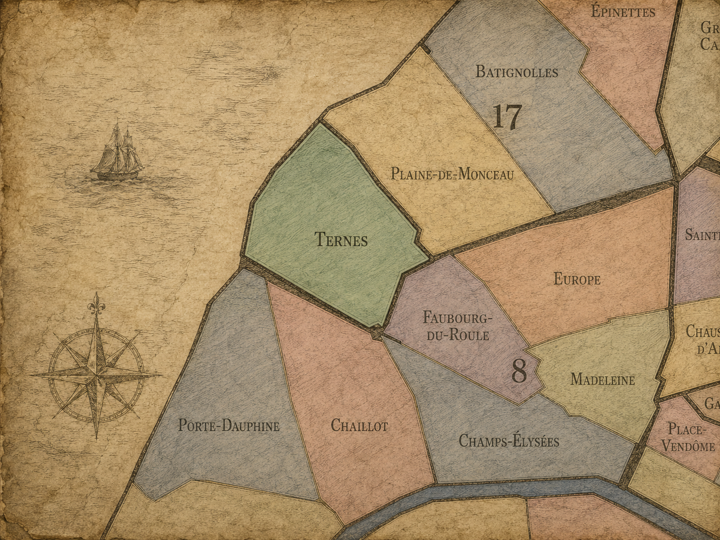
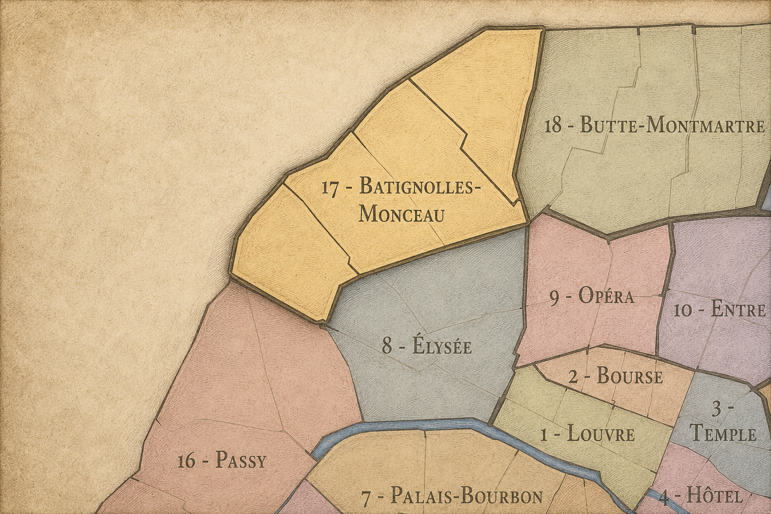
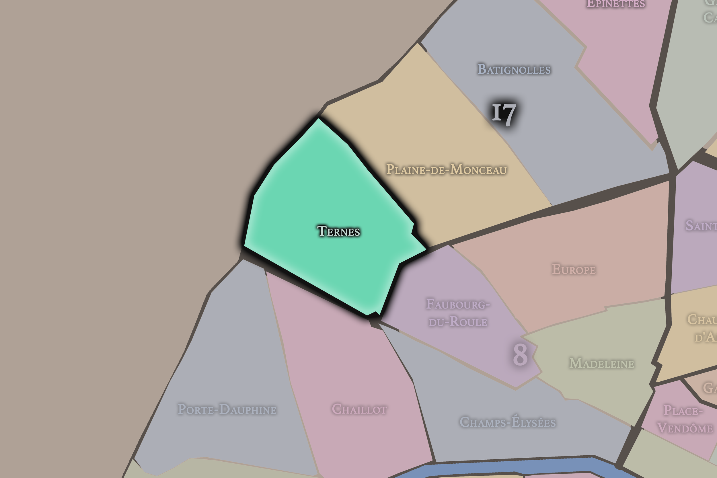
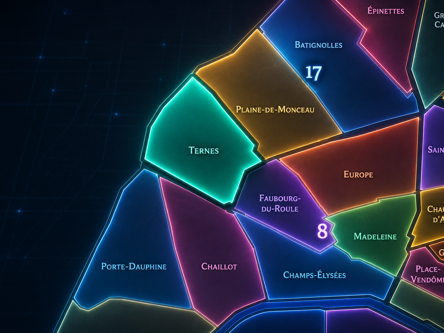
Ternes occupies the southwestern portion of the 17th arrondissement, where the arrondissement meets the Arc de Triomphe, Avenue des Ternes, Porte Maillot, Boulevard Pereire, and the prestigious western routes leading toward Neuilly-sur-Seine. It lies west of Plaine-de-Monceaux, southwest of Batignolles and Épinettes, north of the 8th arrondissement’s Faubourg-du-Roule and Champs-Élysées landscapes, and east of the metropolitan edge around Porte Maillot. This is the 17th arrondissement at its most western-facing: residential, commercial, well-connected, and shaped by the grand geography of arrival into Paris from the northwest.
The quarter’s defining streets and landmarks include Avenue des Ternes, Place des Ternes, Boulevard de Courcelles, Avenue de Wagram, Boulevard Pereire, Rue Bayen, Rue Poncelet, Rue Laugier, Rue Guersant, Rue Pierre-Demours, Porte Maillot, and the approaches to the Arc de Triomphe. Rue Poncelet and the surrounding market streets give Ternes one of its strongest lived identities, balancing the grandeur of nearby avenues with a more local, food-market and neighborhood-commerce rhythm.
Unlike Plaine-de-Monceaux, whose identity is more purely residential, Haussmannian, and park-adjacent, or Batignolles, whose character is more village-like and sociable, Ternes is more openly a threshold quarter of western Paris. It gathers the energy of major roads, business movement, affluent residential streets, and local commercial life into one district. It is the 17th as western gateway — not quite the ceremonial center, not quite the suburb, but a composed and active passage between the two.
Administrative Quarter Identity
Etymology and Origins
The name Ternes comes from the old locality of Les Ternes, a settlement that developed outside the former limits of Paris before being absorbed into the capital. The name predates the modern arrondissement system and preserves the memory of a place that once belonged to the outer western approaches rather than to the dense historic core of the city.
Its exact origin is less immediately transparent than names tied to saints, gates, markets, or churches, which gives it the quality of an old local place-name. Like Batignolles, Auteuil, Passy, or Monceau, Ternes reminds us that the modern map of Paris is built from formerly separate settlements, plains, roads, and villages that were gradually drawn into the capital. The name carries that pre-annexation life forward.
Over time, Ternes became associated less with a village atmosphere and more with a western Parisian crossroads: Avenue des Ternes, Place des Ternes, Porte Maillot, Wagram, and the approaches to the Arc de Triomphe. The old locality became a neighborhood of movement, commerce, residence, and prestige, while the name remained as a quiet marker of the earlier settlement beneath the modern avenues.
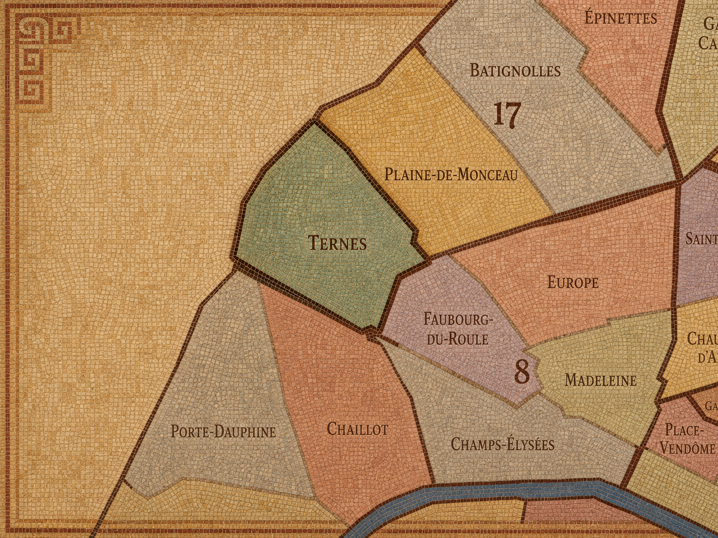
Within the official geography of Paris, Ternes is one of the four administrative quarters of the 17th arrondissement, alongside Batignolles, Épinettes, and Plaine-de-Monceaux. It occupies the arrondissement’s southwestern sector, giving civic shape to the area between the Arc de Triomphe edge, Avenue des Ternes, Porte Maillot, Boulevard Pereire, and the western approaches toward Neuilly.
As an administrative quarter, Ternes clarifies a district often described through stronger local or transit names: Wagram, Porte Maillot, Poncelet, Pereire, Courcelles, or the Arc de Triomphe edge. Each of these names captures part of the neighborhood’s identity, but Ternes is the official frame that gathers them together. It connects the old locality, the market streets, the western gateway, the residential avenues, and the commercial corridors into one mapped unit.
This civic frame is especially useful because Ternes can easily be overshadowed by neighboring icons. The Arc de Triomphe pulls attention just south of the quarter. Porte Maillot draws attention westward. Parc Monceau and Plaine-de-Monceaux shape the eastern imagination. Ternes sits between these stronger landmarks, but it has a distinct civic identity of its own: a western Paris quarter built from commerce, residence, and passage.
Civic Framework
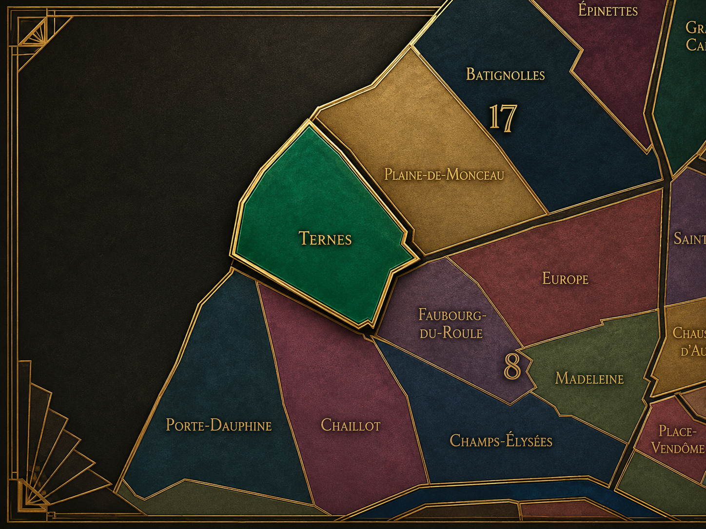
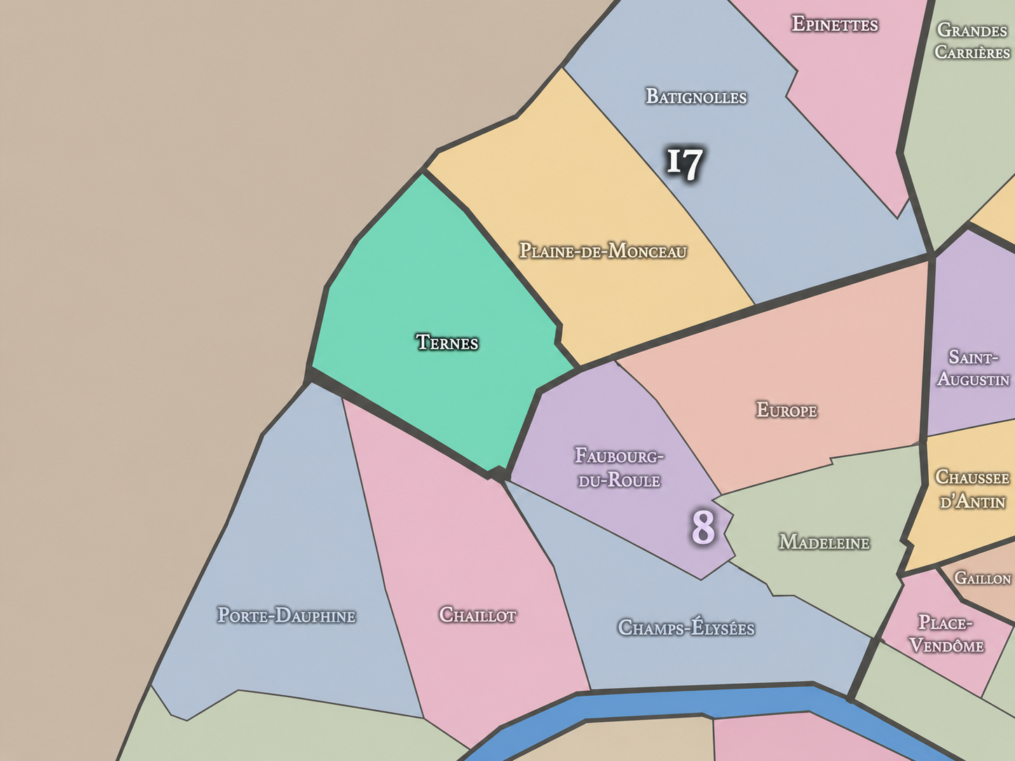
Ternes differs from the other quarters of the 17th arrondissement through its western gateway position, its relationship to Porte Maillot and the Arc de Triomphe, and its mixture of affluent residence with active commercial streets. Plaine-de-Monceaux is more interior, bourgeois, and architecturally composed around the Monceau / Malesherbes / Villiers world. Batignolles is more local, village-like, and associated with cafés, family life, and the newer Clichy-Batignolles transformation. Épinettes is more northern, working-class in memory, and tied to the edge landscapes near Clichy and Saint-Ouen.
Ternes is more outward-facing. Its identity is shaped by roads that move people into and out of Paris: Avenue des Ternes, Avenue de Wagram, Boulevard Pereire, Porte Maillot, and the larger axis toward Neuilly and La Défense. It is a quarter where the city feels residential and local on one street, then immediately metropolitan on the next.
It should also be distinguished from the Champs-Élysées / Arc de Triomphe district. Ternes is adjacent to that monumental western axis, but it is not identical to it. The Arc de Triomphe is ceremonial, touristic, and symbolic; Ternes is more lived, practical, and neighborhood-scaled. It receives the prestige of the western axis, but translates it into market streets, apartment blocks, cafés, offices, and everyday commerce.
Neighborhood Distinction
Parisian Identity
Ternes expresses Paris as a city of elegant thresholds. It is not a former working faubourg in the eastern sense, nor a deeply bohemian district, nor a monumental quarter dominated by one official institution. Its Parisian identity lies in the balance between access and address: a place close to major western landmarks and transport routes, but still grounded in residential and commercial neighborhood life.
The quarter’s strongest lived identity often gathers around Rue Poncelet and its surrounding market streets. There, Ternes becomes less about grand western movement and more about daily Paris: produce stands, fromageries, bakeries, cafés, florists, restaurants, residents shopping, workers passing through, and the recurring rituals of local commerce. This gives the quarter warmth beneath its polished western setting.
At the same time, Ternes belongs unmistakably to affluent western Paris. Its buildings, avenues, professional offices, schools, and proximity to the 8th and 16th arrondissements give it a tone of stability and respectability. It is Paris without bohemian myth or working-edge roughness — composed, connected, and shaped by the long prestige of the northwest.
Neighborhood Connections
Every administrative quarter belongs to a wider Parisian fabric. These connections place Plaine-de-Monceau within the city’s civic, participatory, and cultural geography:
-
17e - Batignolles-Monceau
-

Champerret-Berthier • Courcelles-Wagram • Ternes-Maillot
The History
The origins of Ternes lie in the western outskirts beyond old Paris, where roads, fields, estates, hamlets, and suburban settlements developed outside the city’s older limits. Before it became part of the modern 17th arrondissement, the area belonged to a landscape connected to Neuilly, Monceau, Batignolles-Monceau, and the routes leading toward the western approaches of the capital.
Its early identity was shaped by proximity without incorporation. Ternes was close enough to Paris to be tied to its traffic, commerce, and population growth, but far enough from the historic center to develop as part of the city’s outer belt. Like many former edge settlements, it grew because Paris needed space beyond itself: places for housing, gardens, services, roadside commerce, and movement along major routes.
Ternes’ origin story is therefore one of gradual absorption. It was not founded as a monumental district. It emerged from the city’s expanding edge, then became increasingly urban as roads, residences, commerce, and annexation pulled it into the Parisian map.
Origins
16th–17th Century
In the 16th and 17th centuries, the future Ternes quarter lay outside the dense urban core of Paris. The area formed part of the northwestern plain and western approaches, shaped by rural land, roads, scattered settlement, and the broader geography of villages and estates beyond the city walls. It was not yet a formal urban district, but a landscape of movement and open ground.
This position gave Ternes a different origin from the older central quarters. It did not grow from medieval streets, royal squares, or long-established parish density. It belonged to the outskirts — land that was useful because it lay near Paris, but not yet inside it.
By the end of the 17th century, the western and northwestern approaches to the capital were gaining importance. Elite residences, roads, and the early forms of suburban expansion began to make the area more connected to the city. Ternes’ later identity as a western gateway rested on this long history of being just beyond the urban edge.
In the 18th century, Ternes became more closely tied to the expansion of Paris and the growth of its western approaches. Roads toward Neuilly and the northwest gained greater importance, while the surrounding area developed through residences, gardens, services, and small-scale settlement. The district remained outside the dense center, but it was increasingly shaped by the capital’s movement and social geography.
This was also the period when the western side of Paris became more attractive for elite and bourgeois residence. The area around Monceau, the Champs-Élysées, and the routes toward Neuilly gained prestige, gradually transforming the meaning of the outer northwest. Ternes stood near this emerging geography, positioned to benefit from its later urbanization.
The French Revolution disrupted older property structures and aristocratic landscapes, but the western approaches remained valuable. The roads, open land, and proximity to Paris continued to prepare Ternes for the major 19th-century transformations that would bring it fully into the urban fabric.
18th Century
19th Century
The 19th century transformed Ternes into a Parisian quarter. The expansion of Paris in 1860 incorporated the surrounding communities and former outer lands into the capital, creating the modern 17th arrondissement. Ternes became part of official Paris, but its identity remained strongly tied to the western threshold between the city and Neuilly.
Haussmannian and post-Haussmannian development gave the quarter much of its modern structure. Avenue des Ternes, Avenue de Wagram, Boulevard Pereire, and the surrounding streets became part of a growing residential and commercial district linked to the Arc de Triomphe and the western expansion of Paris. The arrival and development of rail and road infrastructure around Pereire and Porte Maillot strengthened the quarter’s role as a place of circulation.
The 19th century also established Ternes as a bourgeois and commercial neighborhood. Apartment buildings, shops, markets, cafés, and professional life developed alongside the prestige of nearby western axes. Ternes became urban without losing its threshold character: a Parisian district facing outward toward the west.
In the early and mid 20th century, Ternes remained an active residential and commercial quarter of the 17th arrondissement. Its proximity to the Arc de Triomphe, Porte Maillot, and the western avenues made it both prestigious and practical. Residents, office workers, shopkeepers, travelers, and visitors all moved through a district that balanced neighborhood routine with metropolitan movement.
The market streets around Poncelet reinforced the quarter’s local identity. In a district associated with broad avenues and western prestige, the Poncelet area provided a finer-grained urban texture: food shops, cafés, daily errands, and the social life of commercial streets. This helped keep Ternes from becoming merely a transit or prestige corridor.
During the wars, occupation, liberation, and postwar recovery, Ternes shared the complex experiences of western Paris: requisitions, shortages, displacement, continuity, and eventual rebuilding. Its location near major routes and affluent districts gave it a history shaped by both ordinary residential endurance and the larger strategic geography of the city.
Early–Mid 20th Century
Late 20th Century
In the late 20th century, Ternes continued to hold its position as one of the more stable and desirable quarters of the 17th arrondissement. Its residential streets, commercial corridors, access to western Paris, and proximity to major business and transport nodes made it attractive to families, professionals, and businesses. It remained less showy than the Champs-Élysées, but closely connected to that world.
Porte Maillot and the broader western metropolitan corridor became increasingly important during this period, especially with the growth of La Défense and the strengthening of the Paris–Neuilly–western business axis. Ternes stood on the Parisian side of that movement, retaining neighborhood life while being drawn into the larger geography of corporate and commuter Paris.
The quarter’s identity became one of continuity amid growing metropolitan pressure. Traffic, offices, tourism nearby, property values, and commercial change all affected Ternes, but its market streets and residential blocks preserved a strong local structure. It remained a neighborhood, not merely a passage.
In the 21st century, Ternes remains one of the 17th arrondissement’s most connected and livable western quarters. It combines affluent residential streets, active shopping corridors, the Rue Poncelet market area, proximity to the Arc de Triomphe, access to Porte Maillot, and strong links toward Neuilly and La Défense. Its location gives it both local stability and metropolitan reach.
Today, the quarter’s identity is shaped by balance. It is prestigious without being as ceremonial as the Champs-Élysées, commercial without being as overwhelming as central shopping districts, and residential without being secluded. Ternes is one of those Parisian places where ordinary life occurs within immediate reach of national and metropolitan symbols.
For CityNeighborhoods: Paris, Ternes is essential because it shows how an administrative quarter can function as both neighborhood and gateway. It is not simply the edge of the Arc de Triomphe, nor merely the approach to Porte Maillot, nor only the market streets around Poncelet. It is the civic frame where these layers meet: old locality, western avenue, local commerce, residential prestige, and metropolitan passage.
21st Century
Spirit and Legacy
Ternes is the quarter where northwestern Paris turns movement into address. Its spirit is composed, commercial, residential, and western-facing. It belongs to Avenue des Ternes and Rue Poncelet, to Porte Maillot and Boulevard Pereire, to market stalls and apartment façades, to the Arc de Triomphe’s nearby gravity and the road outward toward Neuilly.
Its legacy is the transformation of outer approach into Parisian neighborhood. A locality beyond the old city became a quarter of avenues, markets, residences, and western passage. The threshold did not disappear; it became livable. Ternes retained the energy of movement while grounding it in daily commerce and domestic life.
To walk Ternes is to encounter Paris at a polished edge. The city is not ending here, but turning outward — toward the suburbs, toward business districts, toward the western horizon. Yet the quarter remains unmistakably Parisian in its shops, streets, façades, and routines. In Ternes, neighborhood identity becomes passage made familiar: the western gate transformed into home.
The Photography
The arrondissements do not share a single visual identity. Instead, they organize Paris into twenty broad visual fields, each gathering its own combination of landmarks, streetscapes, institutions, residential districts, commercial corridors, parks, rail stations, markets, cemeteries, and riverfront edges.
Some arrondissements are defined by monumental scale: royal palaces, ceremonial avenues, government buildings, museums, formal gardens, and internationally recognized landmarks. Others are shaped by hills, canals, rail gateways, apartment-lined boulevards, neighborhood markets, former village streets, industrial remnants, parks, or the quieter rhythms of residential Paris. The arrondissement system gives these varied landscapes a civic frame, allowing the city to be read not as one visual language, but as a sequence of overlapping Parisian atmospheres.

Visual Identity
Through The Lens
Photographing the arrondissements means moving between the official map and the street-level experience. The camera does not treat each arrondissement as visually uniform. Instead, it looks for the recurring forms, textures, transitions, and contrasts that make each district legible: the geometry of boulevards, the shade of plane trees, the repetition of balconies, the rise of stairways, the curve of canals, the presence of rail stations, the opening of parks, the weight of monuments, and the intimacy of side streets.
On CityNeighborhoods, the arrondissement provides the frame, but the photograph comes from the encounter between map, movement, light, and observation. As the Paris photography is processed, this section will connect each arrondissement more directly to the project’s Photographic Lexicon: the visual strategies, recurring motifs, and compositional patterns that shape how the city is seen through the lens.

If you visit Paris, these ideas can help inspire your own photography.



Paris: J’Espere, Je Rêve, Je Vive
Paris Photo Gallery
Paris Field Notes
-
Field Note: August 18, 2025 | 07:58 AM
Conditions: 73°F | Humidity: 72%.
Within the park's interior, the glacial kettle ponds acted as humidity traps, creating a soft, hazy light that filtered through the old-growth oaks. The transition from the park's dense shade to the sun-drenched edges of Oakland Gardens highlighted the day's exceptional "picture-perfect" clarity.
There is a fleeting window in Queens where the humidity of August hasn't yet heavy-set, and the morning sun hits the canopy of Alley Pond Park at a perfect oblique angle. Arriving just before 8:00 AM, I watched the light break through the oaks and tulip trees, casting long, dramatic shadows across the wet grass. It’s in these quiet, golden moments that the park feels less like a city escape and more like the ancient glacial valley it actually is.
Other neighborhoods visited:











































































































Explore Paris
-

The twenty arrondissements form the civic spiral of Paris, organizing the city into its broad local districts of government, identity, and daily life.
-

Each arrondissement is divided into four official administrative quarters, giving Paris a more precise civic and geographic framework.
-

The conseils de quartier bring participation to street level, giving residents a voice in neighborhood needs, public space, and local civic life.
-

Les Deux Rives trace Paris through the Seine’s two banks, revealing how the Rive Droite and Rive Gauche shaped the city’s civic power, commerce, learning, art, and cultural identity.
-

Cultural neighborhoods reveal the Paris people recognize through history, cafés, architecture, memory, atmosphere, and local belonging.