
8e - EUROPE
Quartiers Administratifs
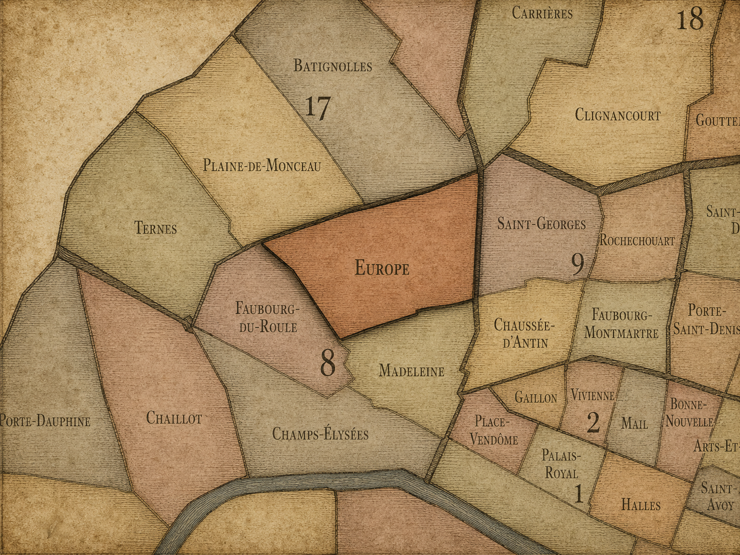
Part of an ongoing project to walk and photograph every neighborhood in Paris, this page explores the Administrative Quarter: 8e - Europe through maps, district identity, history, and photography.




The Map
Download the Paris Arrondissements Map
Geographic Setting
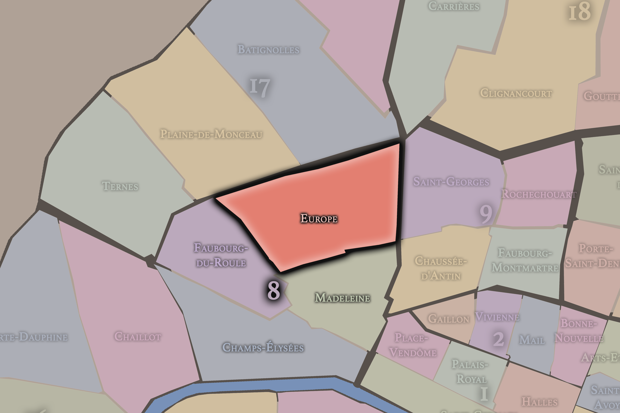
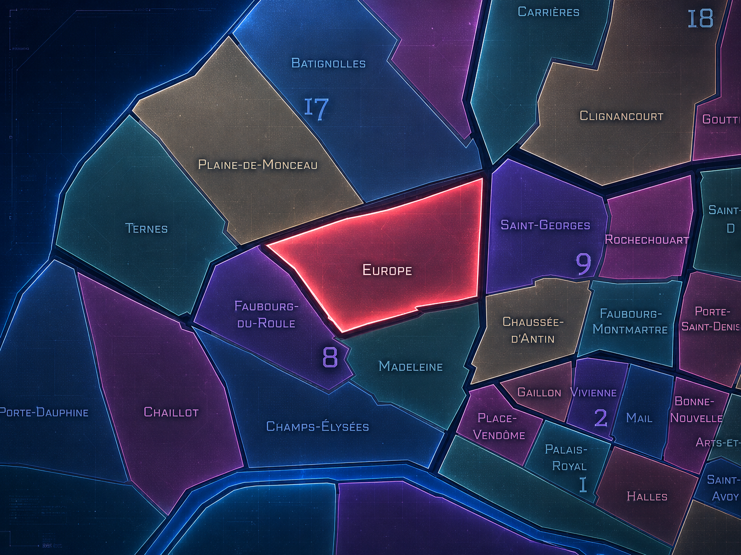
Europe occupies the northeastern portion of the 8th arrondissement, where the formal prestige of western Paris meets the railways, boulevards, apartment blocks, and 19th-century urban expansion around Saint-Lazare. Set north of Madeleine, east of Faubourg-du-Roule, and above the more ceremonial landscapes of Concorde and Champs-Élysées, Europe is one of the 8th arrondissement’s most structurally revealing quarters: a district shaped not by a single monument, but by streets, tracks, stations, bridges, and the disciplined geometry of modern Parisian development.
The quarter’s geography is defined by its relationship to the Gare Saint-Lazare and the distinctive street pattern around Place de l’Europe — Simone Veil, where roads named for European cities gather above and around the railway cut. Rue de Rome, Rue de Madrid, Rue de Vienne, Rue de Londres, Rue d’Amsterdam, Rue de Saint-Pétersbourg, Rue de Constantinople, Rue de Liège, and related streets give the district its unmistakable nomenclature. The result is a quarter where the map itself announces a continental imagination: Paris using the names of Europe to organize one of its great 19th-century railway landscapes.
Unlike Champs-Élysées, whose identity is ceremonial and axial, or Madeleine, whose character is shaped by formal elegance, church, luxury commerce, and the Opéra-Concorde world, Europe is more infrastructural and residential. It belongs to the Paris of rail movement, apartment façades, Haussmannian streets, offices, schools, and the everyday density surrounding a major transportation hub. Its monumentality is less symbolic than structural: the station, the tracks, the bridges, and the street grid all reveal the city as a machine for movement.
Administrative Quarter Identity
Etymology and Origins
The name Europe comes from Place de l’Europe and the surrounding streets named after European cities. This naming system gives the quarter one of the most distinctive identities among Paris’s administrative quarters. Rather than being named for a church, palace, market, saint, former village, or single institution, Europe is named for a geographic idea: the continent itself, translated into a Parisian street network.
The name reflects the 19th-century imagination of Paris as a capital connected outward by rail, commerce, diplomacy, and modern urban planning. Around Saint-Lazare, the names of European cities formed a symbolic geography above the practical geography of train lines. The quarter’s street names turned infrastructure into a map of cultural ambition: Paris as node, gateway, and metropolitan center within a larger European world.
That makes Europe a particularly modern quarter name. It is not rooted in medieval parish life or aristocratic ownership. It belongs to an era of stations, mobility, national capitals, international reference, and urban expansion. The quarter’s name suggests not enclosure, but connection — Paris looking beyond itself while reorganizing itself from within.
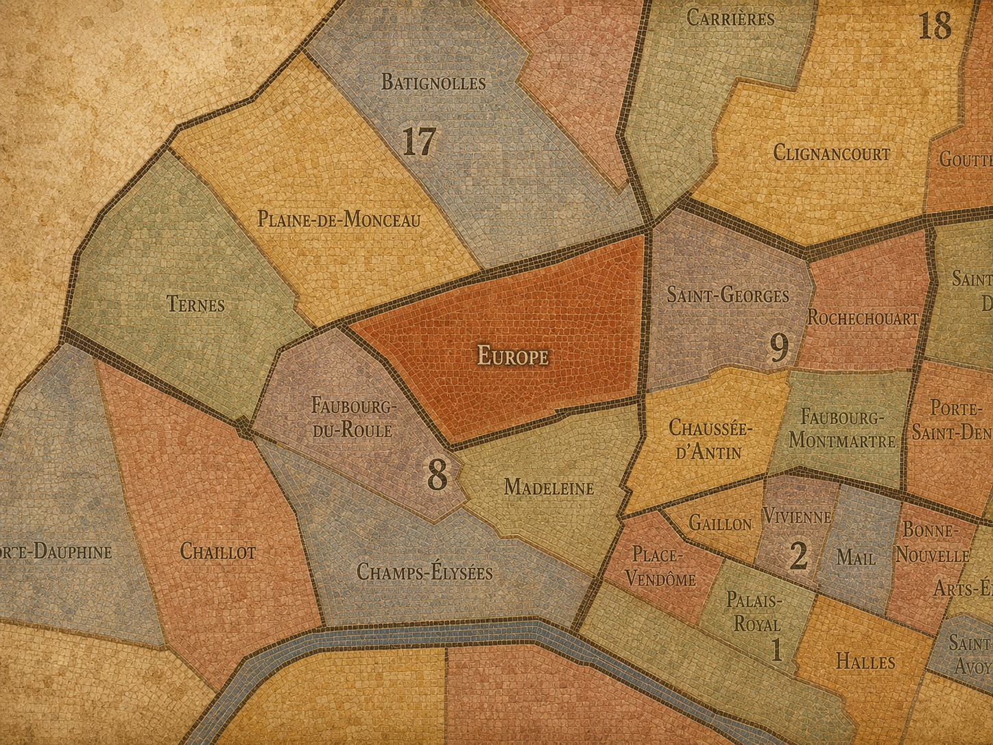
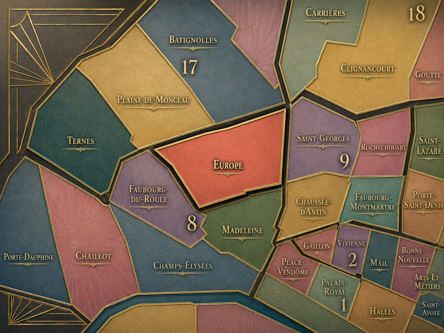
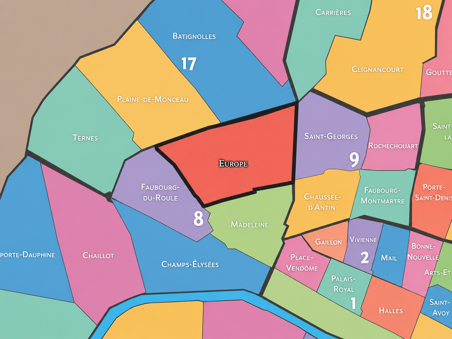
Within the official geography of Paris, Europe is one of the four administrative quarters of the 8th arrondissement, alongside Champs-Élysées, Faubourg-du-Roule, and Madeleine. It occupies the arrondissement’s northeastern sector, bordering the 9th arrondissement to the east and the 17th arrondissement to the north, while connecting southward toward Madeleine and westward toward the residential and prestige corridors of Faubourg-du-Roule.
As an administrative quarter, Europe gives formal civic shape to a district that might otherwise be described through nearby names: Saint-Lazare, Place de l’Europe, Liège, Rome, Villiers-adjacent Paris, the eastern 8th, or the railway quarter. The official name gathers these pieces into one mapped unit, making visible a part of the 8th arrondissement often overshadowed by the Champs-Élysées, the Arc de Triomphe, and the luxury landscapes farther south and west.
Its civic role is especially important because Europe shows another side of the 8th arrondissement. The 8th is often imagined through power, prestige, luxury, diplomacy, and ceremony. Europe adds movement, infrastructure, residence, rail, and 19th-century metropolitan expansion to that picture. It is the quarter that reminds us the 8th is not only an image of grandeur; it is also a working piece of the modern city.
Civic Framework
Europe differs from the other quarters of the 8th arrondissement through its railway identity, residential-commercial fabric, and continental street nomenclature. Champs-Élysées is the arrondissement’s ceremonial stage, shaped by axis, parade, tourism, commerce, and national image. Madeleine is compactly formal, tied to the church, luxury food, Opéra-Concorde elegance, and the western edge of the Grands Boulevards. Faubourg-du-Roule is more closely associated with the upper Champs-Élysées, prestige residential streets, offices, and the transition toward the Arc de Triomphe.
Europe is more infrastructural and urbanistic. Its distinction lies in the way it converts rail geography into neighborhood form. The Gare Saint-Lazare and its tracks cut, organize, and animate the surrounding district. Streets cross and frame the railway landscape, while city names from across Europe turn the local map into a symbolic network. The quarter is not built around one picturesque center, but around movement, connection, and modern urban order.
It should also be distinguished from the broader Saint-Lazare district. Saint-Lazare is a transportation and commercial identity that spills into the 8th and 9th arrondissements, especially around the station, department stores, offices, hotels, and commuter flows. Europe is the official quarter on the 8th arrondissement side of that world, giving administrative precision to a larger zone of rail-driven central Paris.
Neighborhood Distinction
Parisian Identity
Europe expresses Paris as a city of connection. It is one of the places where the capital’s identity is shaped not by stillness, but by departure and arrival. The railways near Saint-Lazare brought suburbs, Normandy routes, commuters, travelers, goods, workers, and new rhythms into the western side of central Paris. The quarter’s streets and bridges did not merely surround the station; they translated the age of rail into urban form.
This gives Europe a Parisian identity unlike the more ceremonial quarters of the 8th. It is refined, but not primarily grand. Central, but not mythic in the same way as Champs-Élysées. It is a quarter where Haussmannian order meets the energy of modern movement: apartment buildings, office blocks, school buildings, hotels, shops, cafés, railway cuts, iron bridges, and the constant sense that the city is being crossed.
The quarter is also deeply visual. The railway trenches and bridges around Place de l’Europe attracted 19th-century artists because they revealed modern Paris with unusual clarity: steam, iron, stone, sky, platforms, signals, and movement. Europe is a quarter where infrastructure became scenery, and where the modern city learned to see itself as beautiful.
Neighborhood Connections
Every administrative quarter belongs to a wider Parisian fabric. These connections place Europe within the city’s civic, participatory, and cultural geography:
-
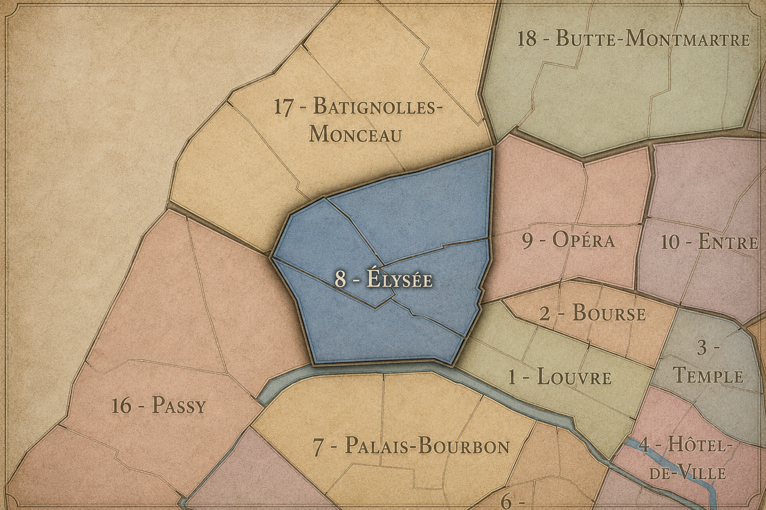
8e - Élysées
-

Élysée-Madeleine • Europe • Monceau • Saint-Augustin • Saint-Philippe-du-Roule
The History
The origins of Europe lie in the northern and western expansion of Paris beyond the older aristocratic and royal core. Before the quarter took on its modern form, this area belonged to the outer landscape north of the Faubourg Saint-Honoré and west of the Grands Boulevards, a zone of fields, roads, estates, gardened properties, and gradual development at the edge of the growing city.
The quarter’s decisive transformation came with the arrival and expansion of rail around Saint-Lazare. The railway required space, engineering, bridges, cuts, and new approaches. It changed not only transportation, but also the surrounding urban fabric. Streets were laid out, real estate developed, and the district became part of the modern metropolitan geography of Paris.
Europe’s origin story is therefore one of conversion from edge to connector. Land that had once stood outside the densest city became a district organized by the technologies and ambitions of the 19th century. Its official name preserves that shift: Paris no longer looking only inward toward court, church, and market, but outward toward a continent of cities.
Origins
16th–17th Century
In the 16th and 17th centuries, the future Europe quarter lay beyond the most densely urbanized parts of Paris. The area north of the Seine and west of the older Right Bank center remained comparatively open, shaped by roads, religious lands, estates, and the gradual outward movement of the city. It did not yet possess the strong identity it would acquire in the 19th century.
This relative openness is important. Many later districts of western Paris were made possible because land beyond the older city could be reorganized at a larger scale. Europe would eventually become one of these planned and infrastructural landscapes, where streets, stations, and bridges could be fitted into a city expanding under modern pressures.
During this early period, the quarter’s future identity was not yet visible. There was no railway, no Place de l’Europe, no network of European city names. But the conditions existed: outer land, proximity to growing elite districts, and enough room for later urban planning to impose a new order.
In the 18th century, the area that would become Europe became increasingly drawn into the expansion of western and northwestern Paris. The development of nearby faubourgs, aristocratic residences, roads, and commercial corridors gradually shifted this landscape from outer edge toward urban district. Yet it remained less symbolically defined than the great squares, boulevards, and palace-related spaces to the south.
This was also the century in which Paris’s western growth became increasingly important. The Faubourg Saint-Honoré, the Madeleine area, and the approaches toward the future 8th arrondissement gained status and structure, while land farther north prepared for later development. Europe’s future would depend on this transition: from peripheral ground to planned modern quarter.
The French Revolution and early modern administrative reorganizations altered the political and civic structure of Paris, but the quarter’s most decisive identity would arrive later, in the railway century. The 18th century laid the groundwork; the 19th gave the quarter its name and form.
18th Century
19th Century
The 19th century created Europe as a modern Parisian quarter. The expansion of the Gare Saint-Lazare and the railway lines serving western France transformed the area physically and symbolically. Tracks cut through the district, bridges crossed them, and new streets were laid out around Place de l’Europe. The naming of streets for European cities gave the district a unified identity and turned the local street grid into a continental reference map.
This was also the century when the quarter entered the artistic imagination. The Gare Saint-Lazare and its surroundings became subjects for painters interested in modern life, including Claude Monet’s celebrated series of Saint-Lazare station paintings. Nearby, artists such as Gustave Caillebotte depicted the modern streets, bridges, and urban perspectives of this part of Paris, helping make railway-era infrastructure part of the visual language of the city.
Haussmannian development and private real estate also shaped the quarter. Apartment buildings, broad streets, offices, and commercial spaces gave Europe the architectural order associated with modern western Paris. The district was not merely the backside of a station; it was a new urban landscape built around the infrastructure of the age.
In the early and mid 20th century, Europe remained strongly tied to Saint-Lazare, commuter movement, offices, hotels, shops, and the residential life of the eastern 8th arrondissement. The station continued to bring flows of people through the district, while the surrounding streets settled into a mixture of bourgeois residence, commercial activity, and institutional use.
The quarter’s railway identity gave it a different rhythm from the more ceremonial spaces of the 8th. It was not only a place to admire; it was a place to pass through, arrive in, commute from, and work around. The railway made Europe modern in a practical sense, structuring daily time through timetables, platforms, departures, and returns.
During the upheavals of war, occupation, liberation, and postwar recovery, Saint-Lazare and its surrounding district remained part of the city’s essential infrastructure. Europe’s identity as a place of movement did not pause. Even under pressure, the quarter continued to function as one of Paris’s important nodes of transport and urban circulation.
Early–Mid 20th Century
Late 20th Century
In the late 20th century, Europe adapted to the changing role of Saint-Lazare and the surrounding business district. Rail travel remained central, but the neighborhood also absorbed new office uses, commercial activity, hotels, and the evolving rhythms of a service-based economy. The quarter’s Haussmannian apartment blocks and institutional buildings continued to give it architectural coherence, while the station area intensified as a hub of movement and commerce.
The district also became part of a broader reconsideration of 19th-century urban heritage. Railway stations, bridges, and Haussmannian streets, once simply signs of modernity, were increasingly valued as historical landscapes in their own right. Europe’s railway cuts, bridges, and named streets gained a more reflective identity: not just infrastructure, but heritage of modern movement.
At the same time, the quarter remained less touristic than Champs-Élysées or Madeleine. Its importance lay in function as much as image. That balance gave Europe a durable urban character: central, elegant, busy, and used, but not overwhelmed by a single monumental attraction.
In the 21st century, Europe remains one of the 8th arrondissement’s most revealing quarters for understanding modern Paris. The Gare Saint-Lazare continues to anchor the district’s movement, while the surrounding streets support offices, residences, schools, hotels, shops, cafés, and institutions. The quarter’s European city names still give the map a distinctive identity, making the urban fabric itself feel like a miniature atlas.
Today, Europe sits at the intersection of heritage and everyday infrastructure. Its 19th-century buildings and railway structures are historic, but they are not obsolete. They continue to organize daily life. Commuters still arrive and depart. Streets still bridge the tracks. Businesses still gather around the station. The quarter remains what it was designed to be: a district of connection.
For CityNeighborhoods: Paris, Europe is essential because it shows how neighborhood identity can be formed by infrastructure without becoming impersonal. Its streets are named for faraway cities, but its identity is deeply local. It is Paris as network — a quarter where rail, architecture, naming, and daily movement turn the modern city into a place.
21st Century
Spirit and Legacy
Europe is the quarter where Paris looks outward. Its spirit is metropolitan, mobile, and precise. It belongs to railway bridges and apartment façades, station clocks and street names, ironwork and stone, commuters and travelers, departures and returns. It is the 8th arrondissement not as ceremonial grandeur, but as urban connection.
Its legacy is the transformation of infrastructure into identity. Rail lines became neighborhood structure. Street names became a continental map. Bridges became viewpoints. A transportation district became one of the clearest expressions of 19th-century Parisian modernity. Europe shows that the city’s beauty is not only in monuments, gardens, or churches, but in the systems that move people through it.
To walk Europe is to encounter Paris as a capital in motion. The quarter reminds us that neighborhoods are not only made by origins, memory, or enclosure. They can also be made by movement — by the tracks beneath the street, the cities written onto the map, and the countless journeys that turn infrastructure into urban life.
The Photography
The arrondissements do not share a single visual identity. Instead, they organize Paris into twenty broad visual fields, each gathering its own combination of landmarks, streetscapes, institutions, residential districts, commercial corridors, parks, rail stations, markets, cemeteries, and riverfront edges.
Some arrondissements are defined by monumental scale: royal palaces, ceremonial avenues, government buildings, museums, formal gardens, and internationally recognized landmarks. Others are shaped by hills, canals, rail gateways, apartment-lined boulevards, neighborhood markets, former village streets, industrial remnants, parks, or the quieter rhythms of residential Paris. The arrondissement system gives these varied landscapes a civic frame, allowing the city to be read not as one visual language, but as a sequence of overlapping Parisian atmospheres.

Visual Identity
Through The Lens
Photographing the arrondissements means moving between the official map and the street-level experience. The camera does not treat each arrondissement as visually uniform. Instead, it looks for the recurring forms, textures, transitions, and contrasts that make each district legible: the geometry of boulevards, the shade of plane trees, the repetition of balconies, the rise of stairways, the curve of canals, the presence of rail stations, the opening of parks, the weight of monuments, and the intimacy of side streets.
On CityNeighborhoods, the arrondissement provides the frame, but the photograph comes from the encounter between map, movement, light, and observation. As the Paris photography is processed, this section will connect each arrondissement more directly to the project’s Photographic Lexicon: the visual strategies, recurring motifs, and compositional patterns that shape how the city is seen through the lens.

If you visit Paris, these ideas can help inspire your own photography.



Paris: J’Espere, Je Rêve, Je Vive
Paris Photo Gallery
Paris Field Notes
-
Field Note: August 18, 2025 | 07:58 AM
Conditions: 73°F | Humidity: 72%.
Within the park's interior, the glacial kettle ponds acted as humidity traps, creating a soft, hazy light that filtered through the old-growth oaks. The transition from the park's dense shade to the sun-drenched edges of Oakland Gardens highlighted the day's exceptional "picture-perfect" clarity.
There is a fleeting window in Queens where the humidity of August hasn't yet heavy-set, and the morning sun hits the canopy of Alley Pond Park at a perfect oblique angle. Arriving just before 8:00 AM, I watched the light break through the oaks and tulip trees, casting long, dramatic shadows across the wet grass. It’s in these quiet, golden moments that the park feels less like a city escape and more like the ancient glacial valley it actually is.
Other neighborhoods visited:











































































































Explore Paris
-

The twenty arrondissements form the civic spiral of Paris, organizing the city into its broad local districts of government, identity, and daily life.
-

Each arrondissement is divided into four official administrative quarters, giving Paris a more precise civic and geographic framework.
-

The conseils de quartier bring participation to street level, giving residents a voice in neighborhood needs, public space, and local civic life.
-

Les Deux Rives trace Paris through the Seine’s two banks, revealing how the Rive Droite and Rive Gauche shaped the city’s civic power, commerce, learning, art, and cultural identity.
-

Cultural neighborhoods reveal the Paris people recognize through history, cafés, architecture, memory, atmosphere, and local belonging.